Measuring
Reality in


high resolution 3D
Harness the power of drones, AI, and IoT to revolutionize the way you monitor, manage, and maintain your projects.
capture| Measure |Transform
Site visits on your fingertips.
DronaMaps is your end-to-end solution for infrastructure and real estate management. We combine cutting-edge drone technology, spatial AI, and IoT sensors to deliver real-time, actionable insights across the entire lifecycle of your project—from planning and construction to ongoing operations. Whether it's highway monitoring or commercial real estate development, DronaMaps helps you achieve efficiency, safety, and sustainability like never before.
Features:
- Accurate 3D Mapping
- AI-Driven Analytics
- Real-Time Monitoring
- Seamless Integration with Existing Systems
The Process
from planning to operations with digital twins

Addressing the lifecycle of your projects
Construction Monitoring
- Progress Tracking
- Change Detection
- Milestone Comparisons


Planning and Design
- 3D Drone Mapping
- BIM Integration
- Sensor Planning
Operations and Maintenance
- AI-Driven Surveillance
- Safety & Security Alerts
- Environmental Monitoring
best in class software for large scale drone operations and analytics
DronaMAps: Robust| Versatile|seamless

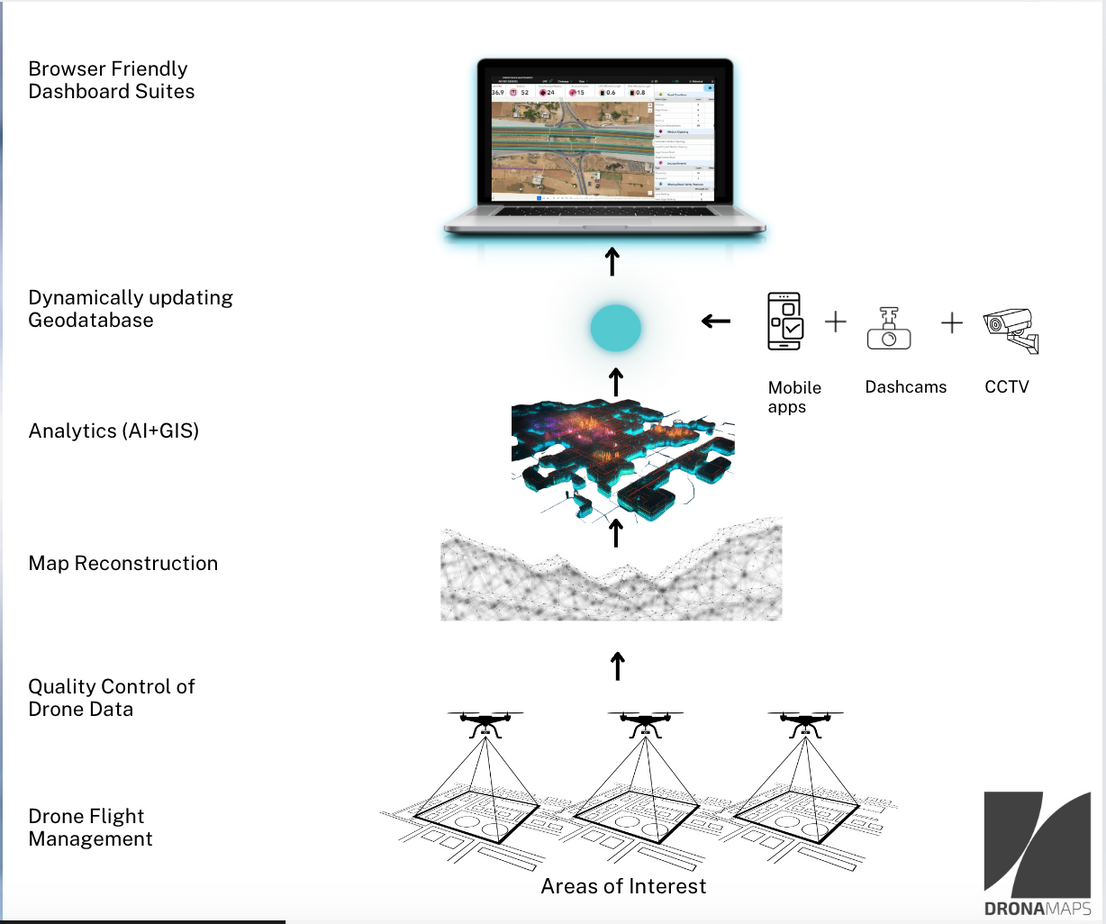
Drone Operations Management
Seamlessly plan and manage drone flights across regions from one platform for efficient coordination. Real-time monitoring feature enables tracking of flights and project progress from a central hub, allowing adjustments as needed.

Data Quality Assurance
Standardization and Validation of Data: Tools for automate quality checks, validate data, and maintain integrity throughout the project lifecycle, ensuring accuracy and consistency of drone-collected data.

Unlimited reconstruction pipeline
Create detailed 3D reconstructions using DronaMaps' powerful engines from drone footage for comprehensive spatial insights without data volume restrictions.
visualise| Analyse| The digital twins of the future
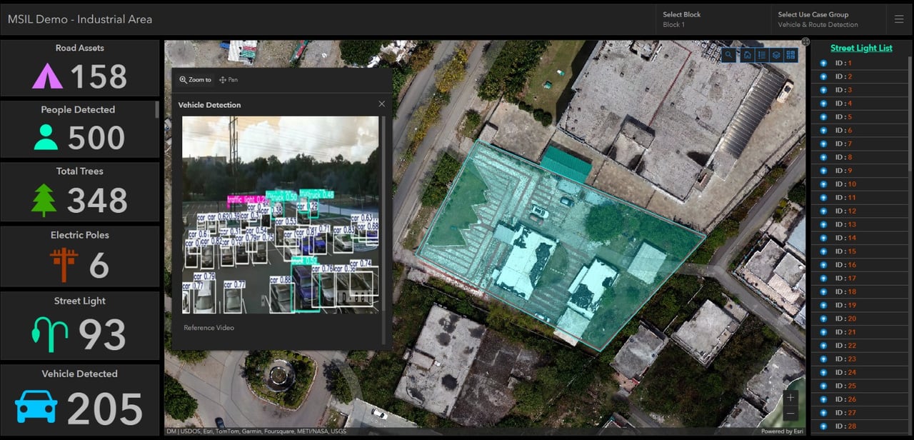

AI Analytics Suites
- AI Analytics Suite provides access to 115 features for tailored insights in detecting structural issues, monitoring environmental changes, and assessing progress in various industries.
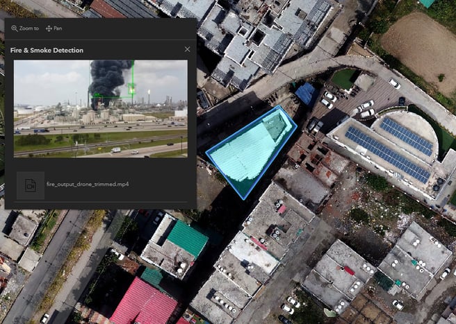
- Utilize advanced video AI for security monitoring to detect unauthorized access, safety violations, and potential hazards, ensuring operational safety with automated alerts and actionable intelligence.

Integrations with CCTV, Dashcam, Mobile Apps, and Drone Videos & Sensors
DronaMaps integrates seamlessly with various video sources and sensors, offering real-time monitoring, mobile and data integration, and enhanced project control for improved project management, safety, security, and efficiency.

Dashboards and digital twins
DronaMaps provides:
- Interactive Decision-Making Tools: Customizable web-based dashboards for visualizing key metrics and making informed decisions.
Sensor-Integrated Digital Twins: Accurate indoor digital twins with sensor integrations for simulations, training, and monitoring complex indoor environments.
Integrating Drone Technology into your workflows
Seamless integrations
Seamless Integrations DronaMaps effortlessly integrates with your existing workflows, ensuring smooth and uninterrupted operations. Whether it's BIM data, IoT sensors, or real-time video feeds from drones, our platform is designed to harmonize with the tools you already use. We eliminate the hassle of switching between systems, allowing you to seamlessly connect all your data sources in one powerful platform.
Intuitive user interface
We believe that advanced technology should be accessible to everyone. That’s why DronaMaps is built with an intuitive, user-friendly interface that makes complex tasks simple. Navigate through high-resolution 3D maps, schedule operations, and analyze data with just a few clicks. No steep learning curve—just an experience designed to empower you to get the most out of your projects.
Excellent customer support
Our dedicated customer support team is always ready to assist you, whether it’s onboarding, troubleshooting, or optimizing your use of the platform.
Empowering Diverse Industries with drone Technology
Real Estate and Urban Development
Transform the way you plan, build, and manage properties with Digital Twins and AI.
Infrastructure and Construction
Ensure your projects stay on track and within budget, with monitoring and advanced analytics.
Highway Agriculture and Environmental Management
Enhance yield, manage farm inputs and track environmental initiatives with state of the art Spatial AI.
Mining
Improve operational efficiency, ensure safety, and manage resources effectively with advanced drone-based surveying and AI-powered analysis.
Bringing dynamically updating geodataBASes to the remotest corners of the country.
"The goal of the creation of one GIS database with integrated master plans is to ensure that the present and future of the state is captured in a standardised database. Geotagged images, property data, and payment history has helped in identification of tax defaulters, highlighting properties where areas do not corroborate with observations on the ground, geotagged images and drone based maps."
Anoop Kaur, Manager (Urban Planning) Punjab Municipal Infrastructure Development Company
drones and AI analytics to POWER decision making in governaNCE
DronaMaps has worked across departments to develop over a hundred web applications spanning multiple functionalities like Mandis, Road Management, Property Taxes for Urban Local bodies, COVID-19 etc.”
Parminder Pal Singh Sandhu, Director, Department of Governance Reforms and Public Grievances.
Cutting edge technology built for the grassroots.
Clients

Contact us